


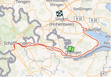
Stein Am Rhein - Singen (par les chuttes du Rhin)

norihtom
User

Length
79 km

Max alt
461 m

Uphill gradient
842 m
Km-Effort
90 km

Min alt
379 m

Downhill gradient
815 m
Boucle
No
Creation date :
2020-02-26 11:15:11.291
Updated on :
2020-02-26 11:17:51.954
--
Difficulty : Very easy

FREE GPS app for hiking
 SityTrail
IGN / Geographical institutes
SityTrail Plus
The world is yours!
About
Trail Bicycle tourism of 79 km to be discovered at Schaffhausen, Unknown, Stein am Rhein. This trail is proposed by norihtom.
Description
Tour du lac de Constance - étape 5
Positioning
Country:
Switzerland
Region :
Schaffhausen
Department/Province :
Unknown
Municipality :
Stein am Rhein
Location:
Unknown
Start:(Dec)
Start:(UTM)
489359 ; 5278226 (32T) N.
Comments